Future cartographers from St Petersburg University: The field placement has been a crucial step in building my professional career path
Conducting aerial surveys of territories, creating interactive maps of Russian regions and airfield maps, and establishing points on geodetic control networks are tasks that cartography students from St Petersburg University complete during their field placement. Students in the Cartography and Geoinformatics programme shared how working on real-life tasks helps them acquire essential professional skills.
Olesia Abakumova
I completed my field placement at Geoscan Group. My primary task was to perform aerial photography of specific territories (on Sakhalin Island and in the Moscow Region) to create orthophoto maps and other cartographic materials. Before each of the aerial photography flights, it was necessary to conduct a ground compilation survey, which is a crucial part of the task and requires a significant amount of time. Other tasks I found particularly interesting included organising drone flights and developing an optimal mapping plan to enhance work efficiency and speed.
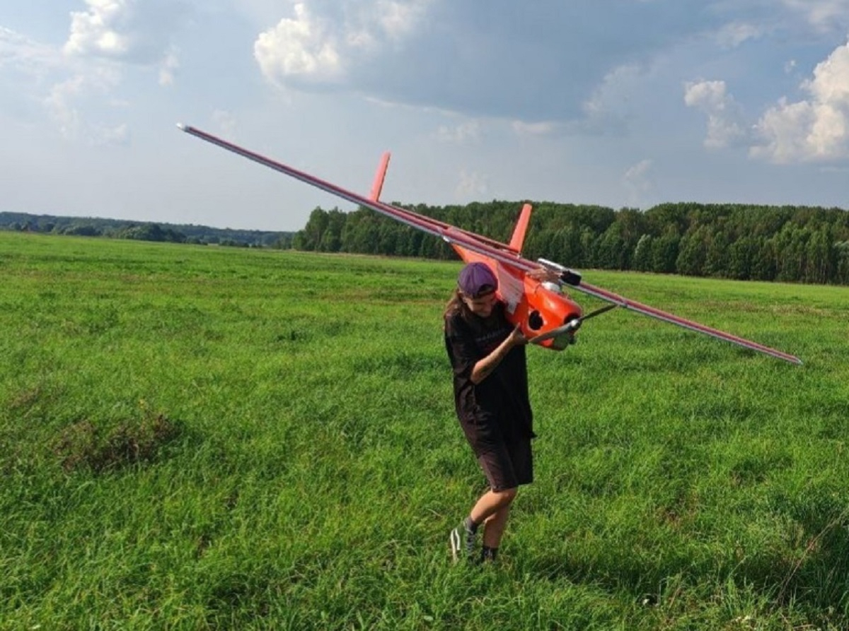
The theoretical knowledge gained at the University certainly helps in understanding many processes. In practice, however, additional tasks and nuances often arise that theory does not always cover, and finding the right solutions comes with experience. For instance, I actively applied my knowledge when conducting ground compilation surveys. But when it came to flights, I had to learn many things from scratch, such as how different models of unmanned aerial vehicles (UAVs) are controlled and should be prepared for a flight, as each model has its unique characteristics.
The field placement provided me with valuable and diverse experiences. I observed the work processes in my professional field and acquired new skills, complementing the theoretical knowledge and practical skills gained at the University. Additionally, I participated in project work, travelled on business trips, and had the opportunity to visit new places, which is especially valuable for a geography student.
Igor Dolgov
Field placement is an excellent opportunity to immerse oneself in professional activities and acquire valuable new knowledge. St Petersburg University provides students in the Cartography and Geoinformatics programme with both theoretical knowledge and practical skills. Nonetheless, an equally important aspect of education is preparation for real-life work after graduation. This is the primary goal of the field placement organised for students after their third year at the University.

I completed the field placement programme at the Research Project Institute of Spatial Planning "ENKO" — an organisation with decades of experience in urban and territorial planning. The Institute’s primary focus is the development of urban planning documentation, which includes several types of plans. These include: territorial planning maps for subjects of the Russian Federation, such as republics, krais, regions, and municipal districts; and general plans for urban districts, urban settlements, rural settlements, and other types of settlements. These plans are created using Geographical Information System (GIS) technologies and methods, which are relatively new to Russia.
During my placement, I worked on developing the territorial planning documentation for Khabarovsk Krai. The primary goal was to create an interactive map with the approved infrastructure, based on the existing regional plan. In completing this territorial plan, I had to solve several challenges. One of the most interesting tasks was arranging the final layers on the NextGIS platform. This step was crucial in creating the interactive map of the region’s infrastructure, as it enabled me to integrate all the prepared materials into the final product.
Although I had to learn the specifics of handling urban planning documentation and its design rules, I had already acquired most of the necessary knowledge about working with geographical information systems at the Institute of Earth Sciences at St Petersburg University. However, due to the wide variety of tools available in GIS, I needed to consult additional sources, which was both interesting and time-consuming. The knowledge I had acquired at the University provided me with the confidence and precision required to complete my assignments effectively.
During my field placement, I gained valuable experience in various areas of cartography. First of all, I enhanced my skills in working with geographical information systems to perform practical tasks such as infrastructure mapping, georeferencing, and styling. I also delved into the relatively new for me field of interactive maps. Particularly valuable was the opportunity to explore urban and territorial planning, which is an area of my personal interest. I learned the nuances of handling professional documentation and the specifics of working in this area. Overall, the placement has been a crucial step in building my professional career path.
Sofiia Makhortova
I completed my field placement at Avia Briefing, an aircraft navigation systems support company. I had the opportunity to work in the Air Navigation Databases Department as a member of a team that focuses on the production of airfield plans. This involved several assignments, including the vectorisation of mapping data and the creation of aerodrome mapping databases. The most interesting of these tasks for me was the automation of processes for inputting and retrieving information from spatial databases, which I initiated.
The knowledge I gained at the University enabled me to start working immediately, without the need for additional training in specialised software. The main challenge in my case was due to the narrow focus of the chosen field placement programme. I therefore had to study certain aspects of aircraft navigation in detail to perform my duties effectively. When using new software or tools in familiar applications, I was able to understand them quickly thanks to the fact that at the University we were exposed to a wide variety of previously unknown software.
I consider the ability to adapt and quickly learn new things as one of the most important skills I acquired at the University, and it proved invaluable when tackling real-life professional assignments.
During my field placement, I learned to interact effectively with my employer and team. I gained experience in work that is a crucial link in a large production chain, where all stages are interconnected. Most importantly, I had the opportunity to show initiative and take responsibility for the outcomes of my work. Additionally, I acquired new knowledge and professional skills that will be useful in my future studies and professional activities.
Igor Florinskii
I completed my field placement at a branch of the Public Law Company Roskadastr Aerogeodezia. Currently, the company, founded in 1920, implements national programmes in geodesy and cartography, not only in the Northwestern Federal District but also across Russia, including Khanty-Mansiysk Autonomous Okrug, the Vladimir Region, the Orenburg Region, the Tambov Region, the Tver Region, the Republic of Tatarstan, the Republic of Bashkortostan, the archipelagos of Novaya Zemlya and Franz Josef Land, and Sakhalin Island. During my placement, I worked on ground compilation surveys for aerial photography and established points for the first-class satellite geodetic control network.
The second part of my field placement programme was the most interesting and exciting. It involved making daily measurements using Global Navigation Satellite System (GNSS) receivers in the Republic of Karelia and the Murmansk Region. Prior to that, I had to examine specific points on the state geodetic control network and the main ground compilation survey (Editor’s Note: global navigation satellite systems have been designed to determine geographical coordinates and include systems like GLONASS and GPS).
The knowledge acquired at the University forms the solid foundation for your professional activities. In order to successfully plan and conduct mapping, it is essential to fully understand the entire work process. Both practical skills in working with geographical information systems and various data types, as well as theoretical knowledge, prove to be in demand. In fact, these skills and knowledge are instrumental in organising your activities effectively to achieve results that meet your employer’s requirements and expectations. Great deal of knowledge from various disciplines was valuable during the placement.
In addition to reinforcing the skills I learned during my University studies, I was able to acquire new ones. The work process and its nuances became clearer to me. Beyond new knowledge and skills, I gained invaluable experience living and working on business trips, and I had the opportunity to visit different regions of our country. This experience is particularly important for a student at the Institute of Earth Sciences at St Petersburg University.